When I put this word into google to reserach the arch, I also wanted to immediately know what it means. The translation from Apache to English came up first. Translation = Stagnant Dirty Water. Old Stagnant Dirty Water.
Did I hear that right?
Sure enough, I read it many times to confirm. We’ll get back to that point after a little bit.
The history on this was a little tricky to read. The arch seems to be in the middle of nowhere, but I’m sure that at one time it leads lots of places. Farmers needed access to places, and miners needed access to other places.
But what do you do when the Earth gets in your way? You tunnel it of course. The history of the Pass and the Tunnel are absolutely intriquing. I only wish I had know all of this when we found this pass exploring Highway 12.
The Highway of Legends.
Obviously, that should have been my first clue that what we find will be amazing.
Back to one of the coolest stories for roads being build I think I’ve come across yet. The stories almost always begin in the mountains for me…
Here’s what I found of Cordova Pass and Apishapa Arch.
The Spanish Peaks are geoloical formations with hundreds of dikes running outward from them. They were formed when a lava flowed into a cracks and solidified. The rock wall that was left after erosion is also the same feature known as the Devil’s Stairsteps, just another “line” of lava filled cracks. If you look at the West Spanish Peak on satellite, you can see the pinwheel of volcanic dykes spread out like a wagon wheel. The Devil’s Stairsteps are on one side of the pinwheel and the Apishapa Arch is on another.
These pinwheel dikes are a new concept to me, we all gotta start somewhere I suppose, Facebook groups have taught me so much, including this recently. In my 50 years of learning, I never once realized that whis is what I was seeing on maps.
These rock walls are fascinating to view, there are many, many of them in colorado, you just need to kinda know what to watch for (Thanks for the guidance Rockhounds). They are lines of rock jutting up, different from their surroundings. Disclaimer here, I am not a geologist, or a rock expert, I just like to read. I’m betting lots of more quailified persons can tell you more about this fascinating event from thousands of years ago than I can…. Anywho….
In 1933 it was decided that the area needed a way through the dike, Cordova Pass could be much faster with that little tunnel.. That lava wall was in the way, so the needed road would need a little modification to the big ass rock wall jutting up in the middle of their plans.
I’m still not certain how the road went around this because Cordova pass came before the tunnel, But I’m sure I’ll discover that answer before I return to the area this coming summer.
The road, as it is now, is remote and fairly rough in places, though I am betting it is really quite the joy ride in the mud. But since it was dry, the road was pretty smooth. Our Beast Ford Excursion handled it just fine and with no needed gear shifting.
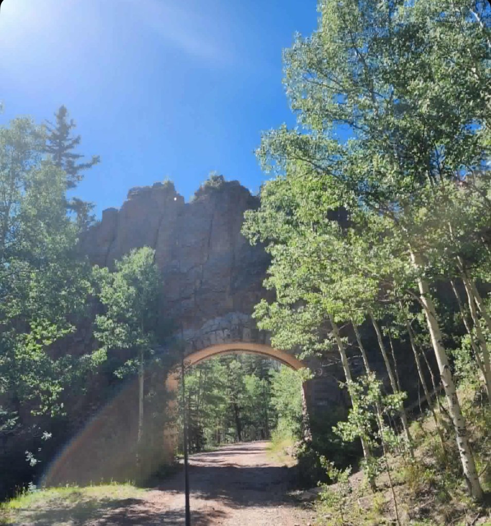
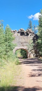
Cordova pass was full of hikers and lots of campers. There were people everywhere. We didn’t stop and continued on the path that said it would lead to the arch. We weren’t sure that we were on the right road and we continued on and all the people sightseeing dissapeared. It was quiet, and eerie. After a short drive, It appeared. The arch was wonderful to see coming around the corner. Definetly on of my “In Awe” moments.
Back to the completion of the arch and the pass. It was made to provide a local ranchers and miners routes that crossed the range easier and faster. Las Animas County Commissioner, Jose De Jesus Cordova fought for the access to the Cuchara Pass area in the late 20s. He served 3 terms on the county seat, once in 1898, again in 1916 and finally in 1928. Every time in office, he wished and worked towards better roads.
As a rancher and leader of the community, it was his dream to see that project completed. He was always looking to improve the roads and the area after moving there from Taos as a young boy.
He pushed for the pass to be built in 1928. He worked tirelessly to gather the funding to build the pass. Then progress halted when he passed away in 1929 right after the project had started.
His son Maurio, continued the effort and the pass was finished in 1934. Coal miners often used this road to travel from Aguilar and Weston upon completion. There is a large monument at the top of the pass, marking his honor that was dedicated to him in 1935.
After it’s completion, it was dedicated to Cordova, but Forest Service removed his monument in 1938 due to land ownership issues. They then renamed it Apishapa Pass, and then renamed it Cordova Pass again later when Fidel Martinez, fought for Cordovas name to reappear in 1977. A new stone was created and installed again in 1985, using the orginal bronze plaque from 1935.
This is probably why it was a little harder to reserach info on it. If you look it up now on maps, I found it under both, as the Pass itself is in a little different location than the arch.
The tunnel through the dike was completed in 1940 for arch. So the math isn’t quite mathing, but I’m trusting the information sources until I hear different. My brain just can’t get over how they got around the rock before the tunnel, it must have been a rough course before that.
Though the tunnel is small in depth, it is still classified as a tunnel. Though I did not know at the time of my visit, you can look up and see the impression of the plywood molds used above on the inner top of the arch. I noticed the grooves, but did not know that was why they are there.
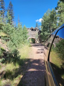
It is no longer the quickest nor easiest way to go from Aguilar to Cuchara. We turned around and went back out after a few miles of fun on the roadds past the arch. I love a great forest road. The Apishapa River was below the arch, and lots of cool rocks to be seen.
We picniced near the Apishapa River on the map, and I have to disagree, it was not smelly, not stagnant. It simply wasn’t really there at all. I take it that we shall need to visit downstream later though. We probably just didn’t know where to to spot the begining of the River, sources say the River is 139 Miles of water. Sources also say that in the Summer, the water pools and becomes stagnant very easily.
Either we are going to question my naviagtion skills (see Gardener Area article) or we are just going to trust that I had us not as close to the river as I thought.
The River flows from West Spanish Peak to Fowler Colorado.
I bet there are other stories of why it was so smelly before though. I’m guessing near the arch is not why.
More to come on the Highway of Legends in the Future, It was simply not enough time in one day to cover then whole area well. We only passed through the arch quickly and back again, as we were pretty far from home.
I will definetly be returning to this area again in the future.
Here are the few photos I got while there!

Leave a comment